Tamilnadu - Tamilnadu Districts - Villupuram District

Villupuram District

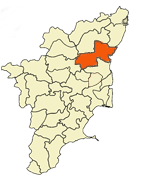
Viluppuram (Tamil: விழுப்புரம்) is a municipality in Villupuram District, in the Indian state of Tamil Nadu. It serves as the headquarters of Villupuram District, the second largest district in the State. National Highway No. 45, from Chennai to Dindigul via Tiruchirapalli, goes through the town. Villupuram also has a major train station. The town's main source of income is agriculture. Its literacy rate was low until the early 1980s. Villupuram District lies in the northeast of Tamil Nadu, between Chennai and Tiruchirapalli. It is 162 km south of Chennai and 157 km north of Tiruchirapalli. It was carved out of the combined South Arcot District in September 1993 and renamed as Villupuram Ramasamy Padayatchiyar District. The remaining part of the South Arcot district became Cuddalore District, which borders it to the east and south. It is bordered to the west by Salem and Dharmapuri districts and to the north by Thiruvannamalai and Kanchipuram Districts.

The greater part of the district contains metamorphic rocks belonging to the Genesis family. There are also three major groups of sedimentary rocks belonging to different geological periods. The Kalvarayan Hills in the north, nearly 40 kilometers from Kallakurichi, represent a continuous range of hills covered with some thorny forests and vegetation. The Gingee Hills offer some of the most beautiful scenery in the district. The Lord Siva in the name of Abath hayeswarar Temple is located in the entrance of Sendamangalam village. This temple is part of the Sendamangalam Koperunchingan kadavarayan king fort.

Vellore-district-map

History

Viluppuram District was earlier a part of Cuddalore District. It was then bifurcated from Cuddalore and became a separate district on 30th September 1993. Because of this, the history of Viluppuram district closely resembles that of Cuddalore. The Cholas were the early rulers. Among these rulers, Karikala Chola was the most famous and powerful. For a short period, the Cholas were overthrown by Simha Vishnu Pallava and the Region came under the Pallava rule for some time. Vijayalaya Chola again revived Chola rule. This was the beginning of great Chola Empire. The later Chola rulers were weak and the power passed on to the hands of Eastern Chalukyas.

Cholas regained their lost position but with the rise of Jatavarman Sundara Pandya-1 (1251 A.D), Chola supremacy came to an end. The sway of Pandyas lasted for over 50 years, followed by Muslim domination from 1334 to 1378 A.D. By 1378, the region came under the rule of Vijayanagar Kingdom and Nayaks were appointed as the rulers of the region. In 1677 Shivaji took Ginjee area with the assistance of Golkonda forces, then after the Mughals came. During the Mughal regime, both the English and French acquired settlements in South Arcot. During the Anglo-French rivalry, the entire district was turned into a war land. After sometime, the entire area came under the control of East India Company. It remained under British authority till 1947 when India became independent.


Country  India
State Tamil Nadu
District(s) Villupuram
Subdistrict Gingee, Thindivanam, Ulundurpettai, Kottakuppam, Kallakurichi
Headquarters Villupuram


Population
Coordinates
906,745 (2,011)
(2011))_region:IN-TN_ 11°56′31″N 79°29′56″E
Language(s) Tamil, English


Area
406 /km2 (1,052 /sq mi)
Temperature
• Summer

• Max. 38.1°C, Min. 24.4°C


Tourist places in Viluppuram


* Gingee Fort
* Kalvarayan Hills
* Tiruvakarai Fossil Wood park
* Anniyur Ramanatheeswarar temple
* Sendamangalam Abath hayeswarar Temple
* Parikal Narashimar Temple
* Villupuram Anjaneyar temple(Fifty-five feet Anjaneyar statue near the temple tank, which is unique in Villupurum district)


Visit the Colleges And Schools Around Viluppuram district Click here