Tamilnadu - Tamilnadu Districts - Kanyakumari District
Kanyakumari District
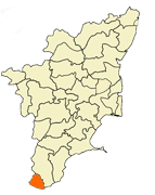
Kanyakumari District கன்னியாகுமரி மாவட்டம் is a district of Tamil Nadu state, India; it is the southernmost land area of mainland India.
Kanyakumari District is the smallest of the 32 districts of Tamil Nadu state. The district takes its name from the tourist town of Kanyakumari, which is at the tip of the Indian Peninsula and faces the Indian Ocean. The administrative capital of the district is Nagercoil, which is 20 km from Kanyakumari town.The district has the best litrecy rate in the state and is considered the best educated district in the indian state of Tamil nadu by the HRD Ministry.It is the third most developed district in the state and is leading in most of the parametersThe District has large population of NRI's in the Gulf. It was ranked third in a comprehensive Economic Environment index ranking of districts in Tamil Nadu not including Chennai prepared by Institute for Financial Management and Research in August 2009. |
|
Coordinates:
Country |
|
|
|
|
Kanyakumari |
|
|
' |
1956,1 November |
|
1,676,034
• 995.7 /km2 (2,579 /sq mi) |
|
M-1000/F-1014 ♂/♀ |
|
87.6% |
|
|
|
1,684 km2 (650 sq mi)
• 68 km (42 mi) |
|
• 1,465 mm (57.7 in)
• 27 °C (81 °F)
• 16 °C (61 °F)
|
Location
Tiruvalluvar statue in Kanyakumari, the southermost town in mainland India
Kanyakumari District is located at the southern tip of peninsular India and bordered by Thiruvananthapuram district of Kerala state to the west and Tirunelveli District of Tamil Nadu to the north and east. It is also sometimes referred to as "Land's End".
The district lies between 77° 15' and 77° 36' of the eastern longitudes and 8° 03' and 8° 35' of the northern Latitudes. The south-eastern boundary is the Gulf of Mannar while on the South and the South West, the boundaries are the Indian Ocean and the Arabian Sea.