History
Dharmapuri District was created in 1966, when it was separated from Salem District. Krishnagiri District was formerly part of Dharmapuri, becoming a separate district in 2004.
The earliest known chieftain who ruled Tagadur (present Dharmapuri) during the Sangam era, is Adigaman Naduman Anji, whose patronage sustained the famous poetess Avvaiyar. The next we hear in the 8th century when the northern parts of Salem District were probably under the Pallavas regime. Subsequently, we hear of the Ganga Pallavas having sway over the Western parts of the Salem District. The Western Gangas are also mentioned as having ruled Baramahal during the end of the 8th century.
In the beginning of the 9th Century, the Rashtrakutas gained power and influenced the history of the district for the next two centuries. During the period, the Cholas also rose to power in the south and Aditya I conquered the Kongunadu in 894 A.D. During 949-950 A.D., the Cholas suffered a defeat from the Rasthrakutas whose decline started later after the death of their king Krishna III. Subsequently, the entire area in Salem District came under the rule of the Cholas. The Gangavadi was then annexed to the Chola territory and placed in charge of an Adigaman Tagadur. The 12th century witnessed the decline of the Chola empire when the Hoysalas rose to power and routed the Cholas from Gangavadi. They are said to have captured Kolar, sacked Kotayur and over ran the western parts of Kongunadu. The Baramahal and Talaget areas apparently still remained with the Cholas. But the Adigaman seems to have practically become free and owed only nominal allegiance to the Cholas. Soundrapandia-I assisted the Yadavas in driving out the Hoysala king, Vira Someswara from the Chola territory.
The history of the 13th Century revolve itself between the Hoysalas and the Pandyas. This portion may be added after when they were attacked from the North by the Yadavas, the Hoysalas retreated towards the South in Kongunadu. It is known that Jatavarman Soundrapandian-I assisted the Yadavas in driving out the Hoysalas king, Vira Someswara, from the Chola territory. But it is doubtful whether he made himself master of the Talaghat area as there are records to show that Vira Someswara's son Vira Ramanatha later ruled the whole of Salem District and the Pandiyas were then eclipsed by the Mohammadan emissaries of the Delhi Sultanate.
The rise of Vijayanagar kingdom was seen in the 14th century. In 1365-66 A.D., Bukka-I turned his attention towards the south to overthrow the Mohammedan Sultanate of Madurai. One of these campaigns must have brought Salem District under the Vijayanagar kings. They ruled these parts till 1565 A.D when the glory of the Vijayanagar king was laid in dust by the combined armies of the Deccan Sultans on the field at Talikota Hosur Denkanikota. While Jagaderea Raya of Chennapatna ruled the Baramahal along with Mysore. Meanwhile the ascendancy of the Madurai Nayaks reached its zenith during the time of Tirumalai Nayak who came to power in 1623 A.D. and this tract was placed in charge of Poligars owing allegiance to him. Ramachandra Nayaka, one of his poligars was in charge of Talaimalai, a hill overlooking the Cauvery in the south Namakkal taluk. The Namakkal Fort is said to have been built by them. The Gathi Mudaliars were in charge of the most dangerously exposed province of the Nayak Kingdom with Kaveripuram on the right bank of the Cauvery as their strategic capital commencing one of the principal passes to the Mysore plateau. The centre of then power seems, however to have been Taramangalam where they built a grand edifice of a temple. It is said that their domination extended as far as Talaivasal to the east, Dharapuram in Coimbatore District in the south. The forts of greatest strategic importance held by the Gathi Mudaliars were Omalur and Attur.
Several places in Coimbatore were taken by Kantirave Narasa Raja of Srirangapatnam from Madurai Nayaks in 1611 A.D. After 11 years, he seized Baramahal including Viralahadradurg, Pennagaram, Dharmapuri and Denkanikotta in 1654 A.D., he took over Hosur from Chandra Sankar Dodda Devaraju the king of Mysore wrested Omalur from the Madurai Nayaks. The aggression of Marathas, however checked the power of the Mysore Kings. For a time Baramahal and Talaghat passed into the hands of Marattas. In 1688-89 A.D., Chikka Deva Raya king of Mysore felt strong enough once again to invade Baramahal and wrested Dharmapuri, Manukonda, Omalur Paramathi, Kaveripatinam and Attur were also retrieved by Chika Deva Raya and the whole district of Salem came under his control before his death in 1704 A.D. Meanwhile Abdul Nabikhan of Nawab of Cuddapah extended his possession towards South and by 1714 A.D., he made himself master of the Baramahal.
By about 1750 A.D., Hyder Ali was in power in Mysore Baramahal came under his sway in 1760 A.D. By 1767 A.D., the British Government at Madras planned an attack on Hyder Ali and seized Kaveripattinam without serious opposition. Krishnagiri was then besieged. Meanwhile, reinforcement was brought by Hyder Ali and they drove away the British. Thus, Kaveripattinam was recaptured. Some months later the British made another invasion on the Baramahal. Further, South Dharmapuri, Salem, Attur, Sendamangalam and Namakkal were surrendered to the British without serious difficulties. The victory, however, was shortlived because Hyder Ali soon recaptured Dharmapuri, Denkanikota, Omalur, Salem and Namakkal. During the period of second Mysore war, Salem District was in the hands of Hyder Ali.
The last Mysore war in 1799 added up several places in Hosur Taluk like Nilgiri, Anjetti, Durgam, Ratnagiri and Kelamangalam which were recaptured by British. After the fall of Srirangapatnam in which Tippu Sultan lost his life, the Balaghat area was also added to Salem District.
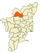
The present Dharmapuri district was then a part of the Salem district. During the British rule in the country and even till 1947 Dharmapuri was one of the Taluks of Salem District. The Dharmapuri district was formed as a separate district on 02/10/1965 with its headquarters at Dharmapuri.
Thiru G.Thirumal I.A.S was the first Collector of Dharmapuri district.
The district has a literacy of 61.39%. This district is one of most under developed districts in Tamil Nadu and lags in all parameters of development. The government has set up a plan to improve the development of the district, including investment.
Dharmapuri is famous for Mangoes. Hogenakal water falls is the famous tourist spot in Dharmapuri District.
District Administration
District Administration is headed by the District Collector. Present District Collector is P. Amutha,I.A.S.,
Divisions
Dharmapuri district comprises two revenue division Dharmapuri and Harur.
There are five taluks namely Dharmapuri, Palacode, Pennagaram, Harur and Pappireddipatti.
There are eleven Urban Local Bodies out of which one is Dharmapuri Municipality and ten Town Panchayats namely Marandahalli, B.Mallapuram, Palacode, Pennagaram, Karimanagalam, Kambainallur, Harur, Papparapatti, Kadathur, Pappireddipatti.
There are eight Panchayat Unions as follows: Dharmapuri, Nallampalli, Palacode, Pennagaram, Karimanagalam, Morappur, Harur, Pappireddipatti. |